

I use MSFS to supplement my real-world flight training, specifically to prepare for my PPL practical exam. I’d like to share a funny story about how I used MSFS to practice diverting to an alternate airfield and ended up completely lost in the virtual skies.
I deliberately chose to share one of my unsuccessful virtual flights rather than a perfect one. By showing my mistakes and how I analysed them, I hope to demonstrate the real value of using MSFS for flight training — it’s a safe place to make errors, learn from them, and improve.
Flight Simulator vs. Reality
Microsoft Flight Simulator (MSFS), as well as X‑Plane, cannot replace real flying. While some visuals look incredibly realistic, the physical sensations of flight are naturally missing. However, a simulator is an excellent tool for practicing procedures. Take emergency training, for example: unlike in a real aircraft, in a virtual environment you can simply cut the engine in mid‑air and run through the entire forced‑landing sequence without any risk. You can use real‑world radio frequencies and squawk codes, and the ground scenery in MSFS 2024 is detailed enough to navigate effectively using VNC (VFR Navigation Charts).
Using a VR headset significantly increases immersion and makes the virtual flight feel much closer to real flying. Of course, we still miss the vestibular sensations and many other physical cues, but the technology is evolving quickly — who knows what we will have in the next 5–10 years
Today my goal is not to simulate the entire PPL practical exam, but mainly its navigation component. The session includes the first VFR leg with full navigation calculations and an airfield diversion, along with a short‑field takeoff exercise. I will describe each of these elements in more detail below.
Flight Preparation
Weather setup
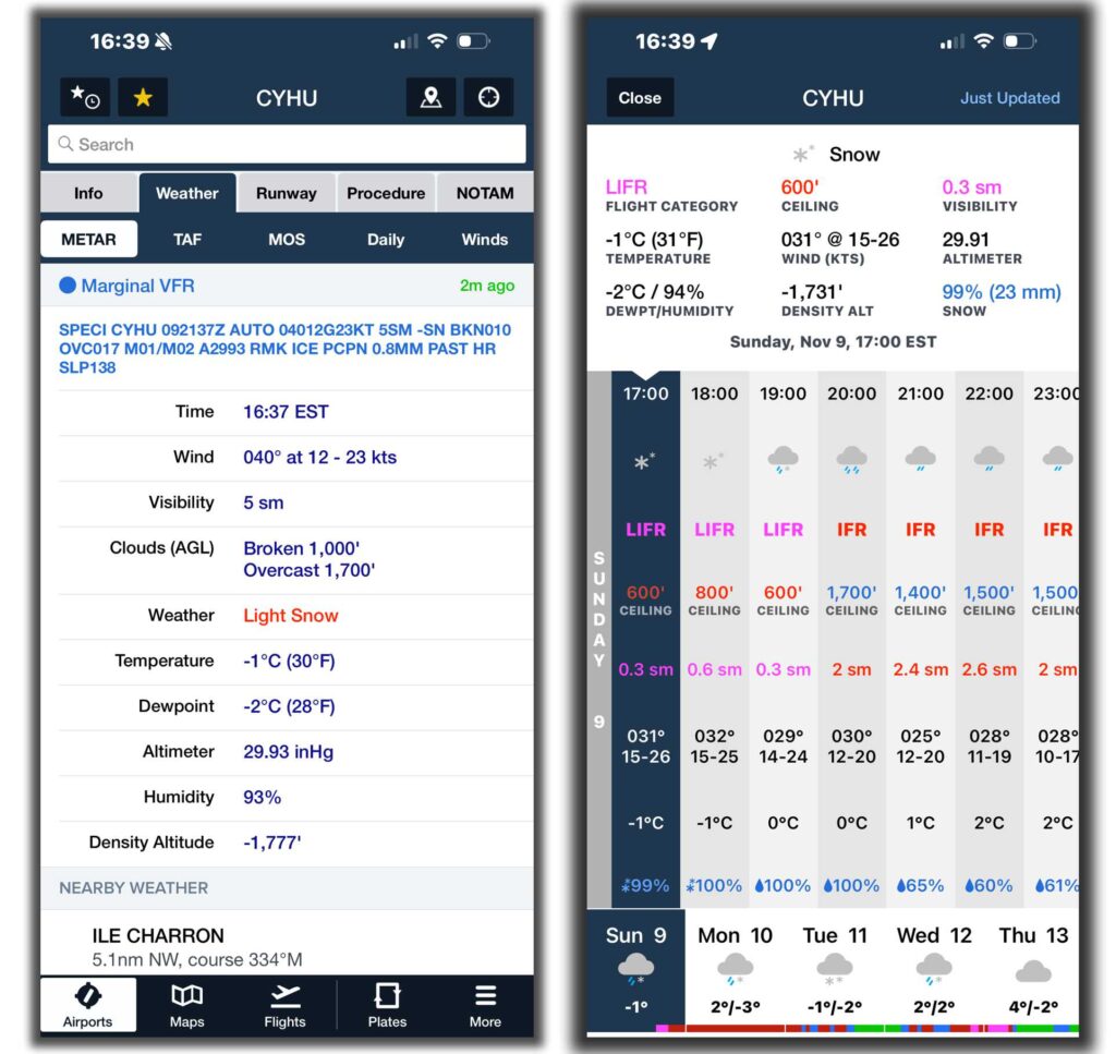
When real-world weather prevents flying — as shown in the screenshot below from ForeFlight (my actual flight that day was cancelled due to low ceilings) — a simulator offers the perfect alternative.
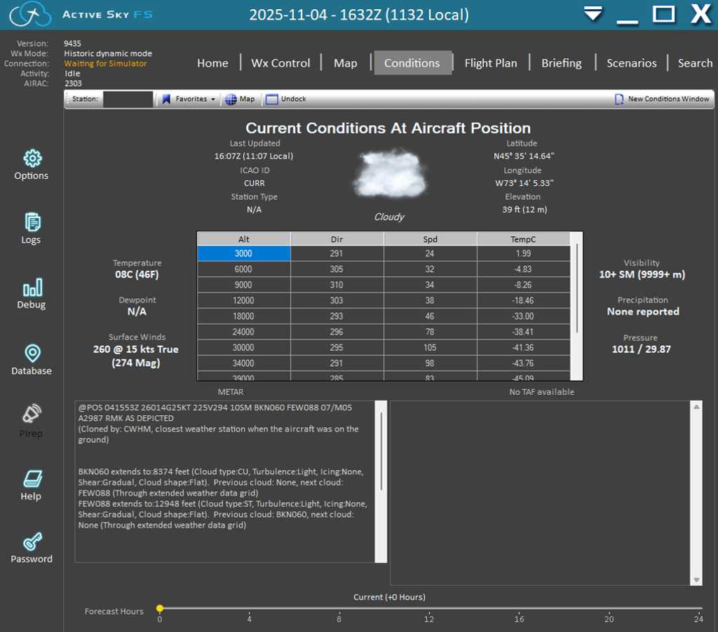
MSFS has its own capable weather engine, and you could simply select clear skies. However, that would feel too artificial. In reality, weather varies along a route, and accurate aloft winds are essential for proper flight planning. I therefore use Active Sky, which injects historical or real-time meteorological data seamlessly. You simply choose the date and time, and it provides everything needed, including evolving TAFs. What’s interesting is that even in Active Sky it can be surprisingly hard to find a day with proper VFR conditions.
Navigation chart
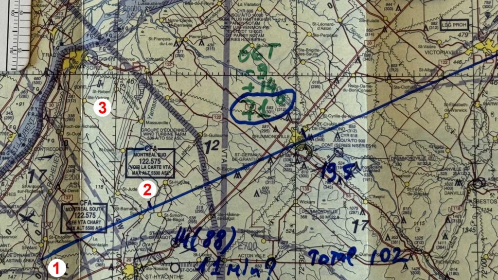
For these training sessions, I use the exact same paper Canada VNC charts that I use in the real aircraft. The goal is serious training, not just entertainment. I plot the route, apply wind correction angles, and perform all calculations by hand (and E6b).
Results and Mistakes Made During the Virtual Flight
Radio procedure errors
After passing the Set Heading Point, I failed to broadcast that I was leaving the Beloeil aerodrome zone on frequency 112.7 MHz. Although Beloeil has no mandatory frequency, announcing intentions is strongly recommended for safety. I also forgot to switch to the Montreal South traffic advisory frequency (122.575 MHz) and make a position report.
Calculations
Ground speed
My ground speed calculation for the first 14 NM leg was incorrect. I timed 7 minutes 50 seconds but mistakenly used 7.5 minutes on the E6B, yielding 112 knots. In reality, 50 seconds is 50/60 ≈ 0.83 minutes, so the correct time is 7.83 minutes and ground speed approximately 107 knots.
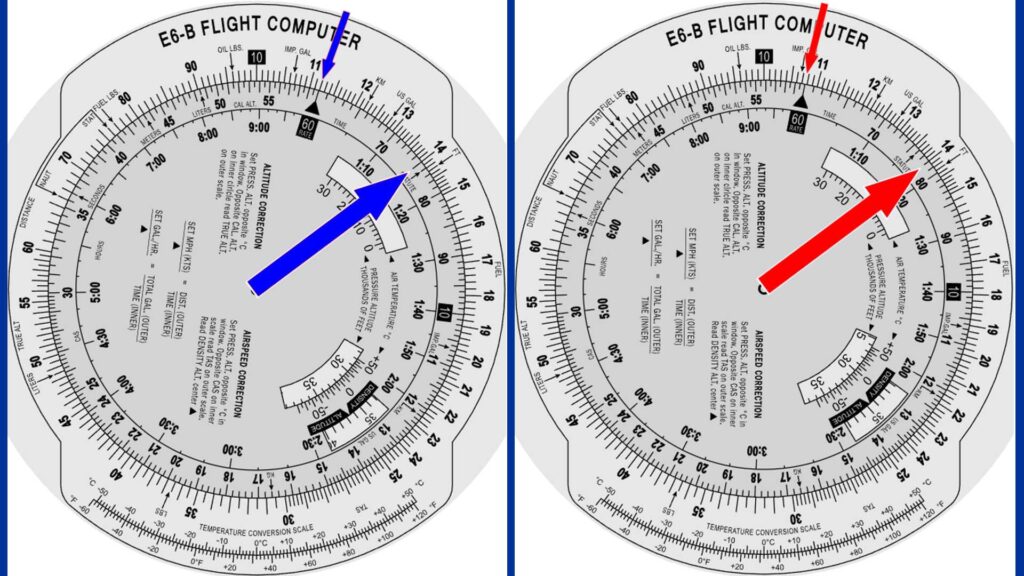
Then I found on E6b that my GS – 112KTS. Well, found that I use 7.5min on the E6B, but 50 sec is NOT 0.5! 30 sec is 50% of the minute – 0.5. We need to divide 50 sec by 60 it will be .08. I.e. the correct GS is 107KTS.
ETA and fuel calculations
I also made an embarrassing error in fuel consumption. I accidentally used the wrong scale on the E6B. With the aircraft burning 7 US gallons per hour, the correct consumption for 7.83 minutes was about 0.98 gallons. Extrapolating to the full 88 NM return route (approximately 47 minutes) gave roughly 5.5 gallons required.
Then calculation how much fuel I have. I had 20 Gal (because I use ), then I consumed 1.1 for taxiing and 7min 50 sec flight – 1.1 gal. I.e. now I should have 17.8 gallons (it will be enough for 2 hours and 30 minutes mandatory reserve for VFR flights).
How I get lost
The diversion task required:
- Precise position awareness.
- Drawing a new course line to the alternate airfield on the chart without additional tools.
- Calculating magnetic heading.
- Measuring distance (using fingers) on the chart scale.
- Checking fuel sufficiency and new ETA.
- Broadcasting the diversion to Flight Service Station (FSS).
I located my position reasonably well, but then made a critical mistake: I had scanned and displayed the VNC chart in the simulator rotated 90° counterclockwise for convenience inside the VR cockpit. I completely forgot about this rotation. Consequently, I calculated a magnetic heading of 274° instead of the correct 347°.
To compound the error, I misidentified Contrecoeur as Sorel-Tracy. In real life, Contrecoeur is unmistakable because of its prominent industrial chimneys (which MSFS does not yet model in detail). I became suspicious when I couldn’t find the distinctive river branch running through the town.
I wasn’t completely lost — I could still have navigated home by following the river or visual references to nearby mountains — but I clearly failed the diversion task.
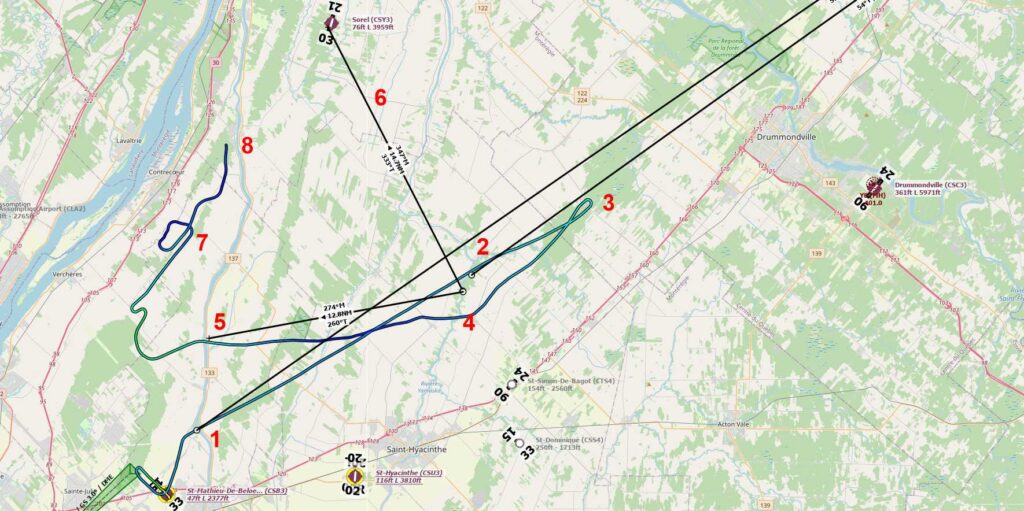
5 – Went along wrogly calculated course (see explanation above) 6 – alternate cours should be like this. 7 – attempts to find Sorel. 8 – I finished the virtual flight when I assume my mistake.
Sorel Airfield from a Distance: Real World vs. MSFS 2024
You might ask: “If you couldn’t find Sorel in the simulator, is it really that difficult to spot in real life?”
Below are two pictures of Sorel airfield taken from roughly 7 NM away and from a similar angle. The seasons are different, but the comparison still shows how challenging it can be to identify the airfield visually.
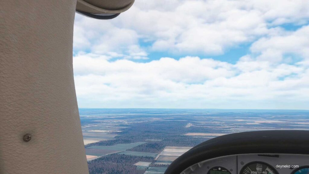
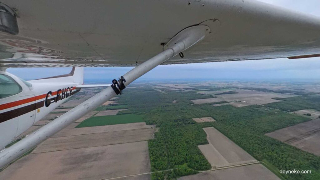
The seasons are different, but the comparison still shows how challenging it can be to identify the airfield visually. Even though the airfield has a few buildings with orange roofs, they are difficult to spot in real flight as well. The airfield is surrounded by dense forest, and the buildings are often hidden from view, especially when seen from the side.
Conclusion: What I Learned from Using MSFS for Flight Training
I made numerous avoidable mistakes that day. None were catastrophic in a simulator, but they highlighted gaps in my procedural discipline. The most important lesson: when using scanned charts in VR, always account for any rotation! Real paper charts, of course, cannot be accidentally turned the wrong way.
MSFS, especially in VR, is an outstanding tool for realistic flight training — provided we treat it seriously and replicate real-world limitations as much as possible.
Alexander Deyneko is a student pilot in the final stages of completing his Private Pilot Licence. Member of the Canadian Owners and Pilots Association (COPA). Has flown the Cessna 152 and 172 and the Schleicher ASK-21 glider, with familiarization flights in the historic Boeing Stearman PT-17 and Harvard Mk. IV. A former paragliding pilot-instructor certified by the Russian United Federation of Ultralight Aviation, where he also founded and ran a private paragliding club. Documentary filmmaker covering aviation subjects, with experience in aerial and 360° video production.
More about the author…